In July 2016, I took an Intro to Mountaineering Course through Yamnuska Mountain Adventures as I was keen to develop some alpine skills so that I would be able to start climbing taller and more complex mountains. On that trip, I met a handful of awesome women who have since become dear friends and adventure buddies! I made it a personal goal to climb at least one 11,000+ ft mountain in the Canadian Rockies every year, and I’m happy to say that I have far exceed that goal since 2016! My 11,000er tick list has been steadily growing, but more importantly, my confidence and skills in the alpine and backcountry are improving as well. I’m hoping to eventually write a trip report for all my 2019 alpine trips, but I’ll kick things off with a trip report about North Victoria, which was my first mountaineering objective of 2019, which I did with Hannah.
First, I want to talk briefly about why I am writing these trip reports. If you don’t care, feel free to skip on to the next section! I’m not a mountain guide, or a professional climber or skier. I don’t have any wilderness certifications other than basic first aid and CPR and avalanche safety (the bare minimum in my opinion for anyone who participates in alpine activities). Who am I then, a novice mountaineer, to be writing these kinds of trip reports? I came up with three main reasons;
- I want to be able to look back on my experiences and adventures in the future and have these memories to keep and share with friends and family and future children. Our minds are notoriously unreliable and recording memories in writing with photos ensures some semblance of accuracy. In this sense, this blog and these trip reports serve as a sort of personal journal, but a cool one with pictures, that I can share with those who are close to me and may be interested in what I’m up to.
- Obviously, a lot of readers or people who come across my blog don’t know me, so they won’t care about what I’m up to! For these people, I want to provide a different perspective on mountaineering/scrambling/the backcountry. When reading trip reports for planning my own adventures, I have found that most of these reports are written typically by men, with superhuman fitness levels (they write things like, “although guide books state the approach will take 5-6 hours, it only took us 3!”), and while informative or have clever storytelling, lack the “learners” perspective. I would like to write about my struggles and the lessons learned just as much as I talk about my successes and achievements.
- As I referenced in my first post on this blog, I want to work on and improve my writing. Fledgling writers are often given the advice to ‘write what you know”, so this gives me an outlet to practice and improve my skill in this arena. So as a note for those looking for a purely informational trip report – this may not be the place for you, as I tend to be a fan of long form, essay-style writing (this may change in the future).
Ok then, let’s get back on track!
Trip Stats
Round trip time and distance: 1.5 Days (or can be done in a single day push in around 12-16 hours) and 21 km round trip
Elevation Gain and Max Elevation: 2,300 m; 3,388 m
About North Victoria
Mount Victoria is probably the most photographed mountain in Canada, although most people don’t know they are even taking a picture of it! It is, of course, that iconic mountain with the long flat ridge and massive glacier that spans the backdrop behind Lake Louise. The long ridge connects the south summit to the north summit, and only around 1000 meters lies between them. While the south summit is higher, the north summit reaches 11,116 ft, and is a worthy mountaineering objective in its own right.
Approach to Bivvy Site
Almost every trip report describes doing North Victoria in a single day push, starting at the Lake Louise parking lot as early as 2 AM! This would inevitably be a very long 12-18 hour day, and since Hannah and I were wanted to set ourselves up for success given this would be our first alpine objective of the season we opted to do this as a two-day trip instead.
To do this, we had to call the Lake Louise Parks office and request a bivvy permit for the night, which costs around $10 per person. They granted the permit to us easily once we explained we were planning to attempt North Victoria.
We drove up to Lake Louise after finishing up work on Friday July 12 and started hiking to the Plain of Six Glaciers trail up to the teahouse by 6 pm. Upon reaching the teahouse, we took a little break to have some water before starting on the trail towards the lookout point. However, about 100-200m from the teahouse, there is a trail that branches off to the right, beside an obvious boulder field. We took this well-trodden trail, which is deceptively steep but the steady switchbacks got us above the treeline in less than an hour. Above the treeline, there were several cairns that guided us through the scree field and moraine to reach the right-hand side edge of the Victoria Glacier.

I’m pretty sure 99% of the reason I even bother mountaineering is for the beautiful bivvy sites! It’s not very often that one has the incredible opportunity to sleep right on the edge of a majestic glacier and watch the setting sun cast its warm golden rays across the valleys below. Hannah and I were also the only people there for the night, and it felt like we were a million miles away from the rest of civilization as we ate our Pad Thai backpackers meal and looked up towards the summit of North Victoria, planning our ascent for the next day.

To the Summit!
Sleep evaded me most of the night. Whistling winds and several passing rain showers pit-pattered and rattled our small two-person tent. When I finally felt my body drift into a semi-conscious dream state, my cell-phone alarm blasted me awake at 3:30 AM. In my zombie state I somehow managed to get dressed properly, which is more than I can say for Hannah who forgot to put on one of her gaiters! Thank goodness, Hannah remembered to pack some caffeine pills (a trick we picked up the year before from a couple guys on our trip to Mount Woolley) which perked us right up as we roped together and started to ascend the lower part of Victoria glacier.
The temperature was surprisingly warm and stayed around 10 degrees Celsius overnight, which meant the snow on the glacier was quite soft and there was no need to use crampons. As we steadily ascended the glacier, the sky started to brighten as dawn arrived, and we were able to see some old tracks in the snow that hadn’t been completely erased by the rain. This was helpful in navigating our way up the glacier, which has many large crevasses that yawn open into a dark abyss if you stray too far to the right or left. We stayed left of a large rock outcropping and continued to the upper part of the glacier which quickly flattened out for easy and quick travelling.
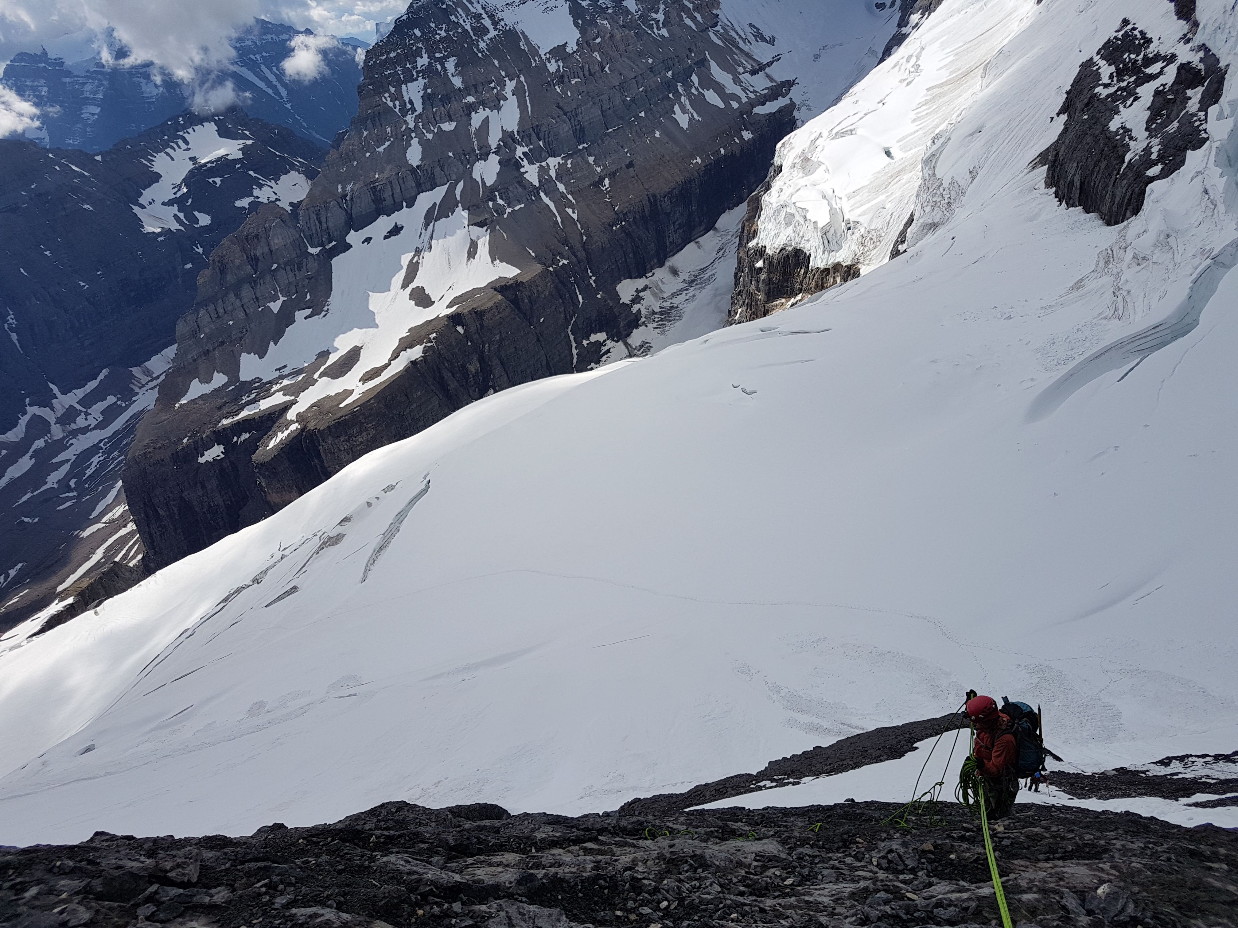
One large obstacle typically looms between the glacier and beginning one’s ascent up to the ridge between North Victoria and Collier Peak, which is a bergshrund that runs across the length of the glacier. A bergshrund is a crevasse that forms between the moving part of the glacier and stagnant ice or headwall rock on the other side. We were fortunate however, because recent avalanche debris filled in a section of the bergshrund, creating a large and supportive snow bridge that we crossed with ease.
The next section was much more difficult however. Referred to as “the black band”, we had to scramble up the steep slope on a treacherous mix alternating steep snow sections and wet rock ledges covered in loose rock debris. Going up required a lot of hands-on scrambling but we moved quickly and confidently up to the snow-covered ridge.

By the time we reached the ridge, the sun was rising above Collier Peak. Earlier I said that my favourite thing about mountaineering was the bivvy site – but reminiscing on this morning, I might have to reevaluate! There is nothing quite like a sunrise high in the alpine – the way the alpenglow enshrouds the mountain peaks with warm shades of blush pinks, violets and rust orange. The way the rays of the sun extend in ribbons of gold across the horizon. The warmth of the sun’s morning glow on your face after trudging up a glacier in the night. The entire world below you illuminates, and the wonders of the earth are finally revealed before you, as far as the eye can see.
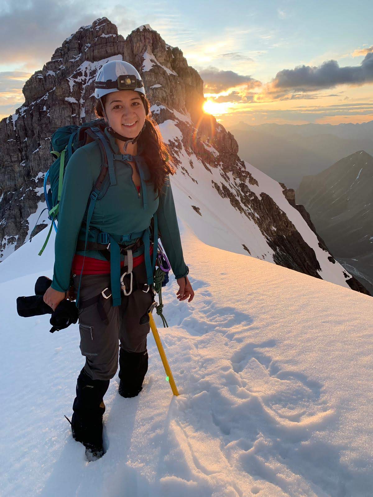
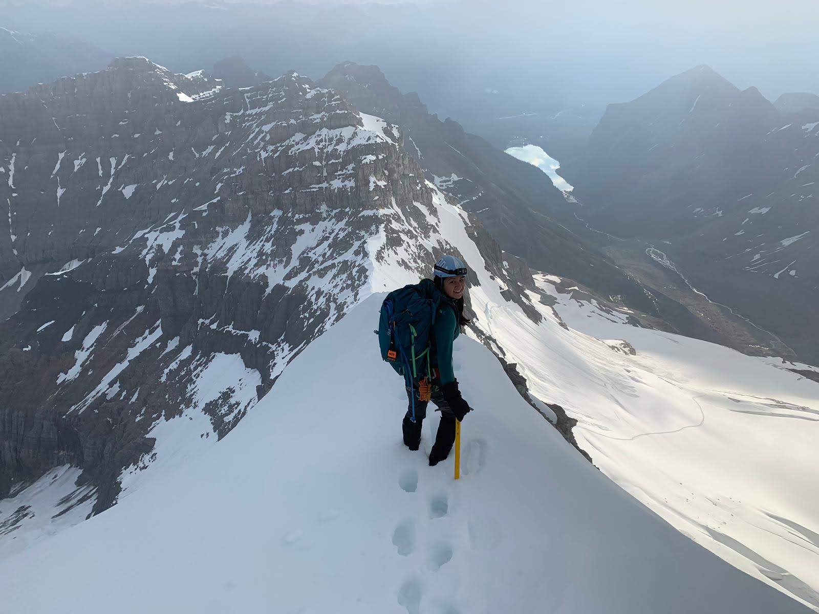
Crossing and ascending the ridge was by far the most scenic part of this trip. Once you start ascending the ridge, there are sections of easy rock scrambling, until you reach a pillar of rock with a 5.3 move on it. This can be bypassed on the right by ascending very steep snow slopes. Given the snow didn’t get a very good overnight freeze, we opted to solo up the 5.3 rock step which felt much, much harder than some 5.8’s I’ve done in sport climbing! It was a good reminder that climbing in heavy soled mountaineering boots, with a pack on your back, on wet cold rock, is not simple, easy or straightforward. Hannah had already climbed up and over the rock step – she has the uncanny ability to let adrenaline take over, and despite admitting to also being terrified, doesn’t freeze up but just marches on forward. I’m the opposite. I found myself temporarily paralyzed halfway up the rock step, my fingers frozen in a death grip on icy rock. I finally managed to step my feet up and pull myself over and on top of the final ledge, breathing a sigh of relief at the top.

Looking back on this section – there were a few things we could’ve done to make the rock step less terrifying. Hannah went first, but I was carrying the rope! Rookie mistake. If I had gotten stuck, there would’ve been no way for her to rappel back down. Or, even though the rock step was short, we had carried a rope this whole way, and could’ve easily belayed each other up this section, as there was a permanent bolt halfway up and a rappel station at the top.
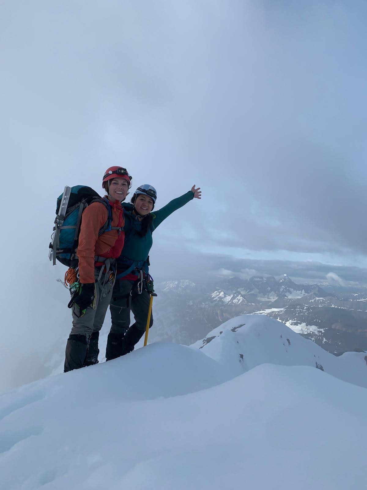
We made it through however, and the rest of the ascent was a straightforward walk up snow to the summit. By the time we reached the top shortly after 7:30 AM, the summit was enshrouded in a cloud, so we didn’t get the best views, however the clouds were mostly clear lower down on the ridge so it’s not like we were missing out too much.
The Descent
As every mountaineer knows, reaching the summit is only half of the journey, and 75% of falls happen during the descent. Fortunately, bringing a rope served us well, since there were several makeshift rappel stations set up along the route. We were able to easily rappel down the 5.3 rock step, as well as the rock scrambling section below to the col.

Descending the “black band” however was significantly worse than ascending it. The snow sections at this point had become sugary and unsupportive. Each step into the snow gave way, and it felt as if we would slide all the way down to the glacier with just one misstep. We opted to scramble down just on rock instead, the first half was painstakingly slow as we were zig-zagging down the band, searching for ledges that had enough room to securely place our feet. About halfway down the black band, we reached another rappel station that we had found during our ascent, and rappelled the rest of the way down to the glacier. Although this probably didn’t save us much time, since setting up the rappel takes a while (we probably need to work on our rope management skills), and we had to descend one at a time, it felt much safer.
Returning to our bivvy once reaching the glacier was straightforward, as we just retraced our steps all the way back to our tent. Upon arriving, we instantly kicked off our boots, and shovelled a bunch of cheese and meat to fill our rumbling bellies. Afterwards, we curled into our warm tent and had a very well-deserved nap before packing up camp and hiking back to the car at Lake Louise; overall, a very successful start to the mountaineering season with a wonderful friend.

One thought on “North Victoria – Kicking off 2019 Summer Mountaineering”